Friday, July 30, 2010

DLR Investigates The Existence Of Liquid Salt Solutions On Mars

0 comments


by Staff Writers
Bonn, Germany (SPX) Jul 29, 2010
Is it possible that there are salt solutions on Mars that remain liquid despite the extremely low temperatures - a class of fluids known as cryobrines? Research findings at the German Aerospace Center have shown that this is a theoretical possibility.

Experiments and modelling have indicated that the required conditions exist, especially during the Martian northern summer at higher latitudes. Prof. Diedrich Mohlmann of the DLR Institute of Planetary Research presented these initial findings on Friday 23 July and Saturday 24 July 2010 at the international COSPAR (Committee on Space Research) 2010 conference in Bremen.

"Our research was triggered by the findings of NASA's Phoenix Mars mission," explained Prof. Mohlmann: "In 2009, scientists showed, with images of salt solution droplets on the Phoenix probe, that cryobrines could exist on Mars. Since there is no liquid water on Mars' surface, cryobrines could possibly be a fluid medium that supports life."

Prof. Mohlmann and his team have discovered that it is possible for the liquefaction of cryobrines during the northern summer at high northern latitudes to last all day. At middle latitudes, the phenomenon occurs over several hours during the morning and evening; this is due to the salts absorbing atmospheric humidity to liquefy - a process known to as deliquescence. A higher degree of humidity prevails during the northern summer, which declines further south.

Encouraging results
Deliquescence may at least temporarily cause liquid salt solutions to form at temperatures far below zero degrees Celsius for part of a day or part of a year. This fact is especially significant since the average night-time temperature on Mars is about minus 80 degrees Celsius.

This liquid solution could allow flow processes, known as rheological processes, on the Martian surface. In the context of possible biological processes, this could also be a life-sustaining transport of nutrition and waste.

These are all qualities that are normally only attributed to water. The question of whether this is sufficient to make life possible is being investigated in the next phase by microbiologists at the Technical University of Berlin together with colleagues from the DLR Institute of Planetary Research.

If life is possible in these temporary liquid salt solutions, the definition of habitability will need to be expanded: 'Pure' water would no longer be the sole prerequisite for the emergence of life.

The DLR and TU Berlin research teams are experimenting with these biological questions within the framework of 'Planetary Evolution and Life', an alliance of the Helmholtz Association.

"We are still at the beginning, but our initial findings are extremely encouraging," declared Prof. Mohlmann, and he continued: "We are currently testing various micro-organisms to examine whether and how they survive in salt solutions. Under terrestrial conditions - that is, with a freezing point of zero degrees Celsius, this has been already explored, but not at temperatures below zero."

www.marsdaily.com

Thursday, July 29, 2010

Panel considers cost of space tourism

0 comments


disclaimer: image is for illustration purposes only
by Staff Writers
Sunnyvale, Calif. (UPI) Jul 27, 2010
U.S. space tourists hoping to buy a ticket for a suborbital flight could expect to pay between $50,000 and $100,000 by 2014, analysts say.

For prices to drop that low, the commercial space tourism industry would have to reach the point of offering thousands of flights per year, SPACE.com reported Tuesday.

Some in the field are optimistic the industry could be offering that many flights in the near future, while others take a more pessimistic view.

"People have put down money to fly on [Virgin Galactic's] SpaceShipTwo, but what is the long-term viability of the market?" A.C. Charania, president of the SpaceWorks Commercial consulting firm, asked. "After those pioneers fly, is this a sustainable service? We have a question on that from the analysis we've done."

The future of the industry was discussed by a panel of experts at the Space Frontier Foundation's annual conference in Sunnyvale, Calif., SPACE.com said.


www.space-travel.com

Hypatia - 4th Century Woman Astronomer

0 comments


The death of Hypatia, and the loss of the world's largest collection of scientific and mathematic writings, were factors that contributed to the halt of scientific advances in the West halt for nearly a thousand years.
by Staff Writers
Washington DC (SPX) Jul 29, 2010
The new movie Agora chronicles the life, challenges and death of Hypatia, a 4th Century woman astronomer whose contribution influenced and shaped modern science and our understanding of the world and the universe. Mabel Armstrong, author of the award-winning book Women Astronomers: Reaching for the Stars, tells Hypatia's story with the joy that a great science teacher (which she was) can bring to an old subject.

When Hypatia was born, her father, Theon, was a professor of mathematics and astronomy in Alexandria. He believed, as many Greeks did, that it was possible to raise a perfect human being. So he gave his daughter the best possible education, including studies in mathematics, languages, rhetoric, and natural philosophy-or science.

Upper-class women of the time were usually secluded, expected to devote themselves solely to their husband and children, but Hypatia found a job at the most famous institution in the ancient world, the library at Alexandria. She taught mathematics, physics, and astronomy, and wrote many books about these subjects-thirteen books on algebra, her favorite subject, and another eight books on geometry.

She also designed an astrolabe, an instrument used to measure the positions of the stars, another important tool for sailors, which let them locate specific stars and use the stars' positions for navigation. She used her astrolabe to calculate the positions of specific stars, and then published her data in tables. Sailors and astronomers used her tables of positions of the stars, Astronomical Canon, for the next 1200 years.

In her classes

and public lectures, Hypatia exhorted people to think critically. "Reserve your right to think," she said. "For even to think wrongly is better than not to think at all."

When Hypatia sided with Orestes, the Roman governor of Egypt, in a power struggle with Cyril, the head of the Christian Church in Alexandria, her enemies decided to silence her. An angry mob, some say sent by Cyril, attacked and murdered her. They beat her with stones, cut her with clam shells, and finally burned her body.

The death of Hypatia, and the loss of the world's largest collection of scientific and mathematic writings, were factors that contributed to the halt of scientific advances in the West halt for nearly a thousand years.

"Astronomy

was never just a man's field," Ms. Armstrong says. "Women have always studied the night sky."

Her book Women Astronomers: Reaching for the Stars, which has received critical praise internationally, examines the remarkable accomplishments of 21 women who struggled with society's narrow ideas on the appropriate roles for women and the incredible challenges each met in her own way.

She describes the stories of some of the fascinating women who dared to look toward the stars-from the earliest known woman astronomers, to Hypatia of Alexandria, to Astronaut Sally Ride and all the fascinating, brave women in between.

www.spacedaily.com

Wednesday, July 28, 2010

Integral Systems Helps DigitalGlobe Enhance Earth Imaging Download Capacity

0 comments


File image.
by Staff Writers
Colorado Springs CO (SPX) Jul 28, 2010
Integral Systems has announced that its wholly-owned subsidiary, RT Logic, has received an order from DigitalGlobe to supply remote high rate data capture systems and Telemetry, Tracking and Control (TT and C) modems to optimize distribution of DigitalGlobe's satellite imagery. The delivery builds upon a successful initial deployment of RT Logic equipment to DigitalGlobe initiated in 2005.

DigitalGlobe originally worked with RT Logic to design and deploy a complete ground system architecture that included both high rate data capture systems, and command and control front-end processing. This included RT Logic's T500HR High Rate Data Processor, T1200HDR High Data Rate Receiver, T70/70XL TT and C Modem, and T500GT Gateway Protocol Translator.

The flexible, scalable architecture is now being expanded with new data capture and TT and C modems to enhance image download capacities from DigitalGlobe's WorldView-1, WorldView-2, and QuickBird satellites. The new systems will support an antenna being installed at the Troll, Antarctica site. Other existing sites at Fairbanks and Prudhoe Bay, Alaska and Norway will also receive the new RT Logic equipment.

"Customers not only need access to a broad array of imagery, but they also need it as fast as possible," said Jeff Culwell, Vice President of Operations at DigitalGlobe.

"The launch of WorldView-2 significantly increased our collection capacity, enabling us to image more than 500 million square kilometers every year. Our work with RT Logic ensures that we can download all of that imagery effectively and efficiently so that our customers can access and apply its valuable insights."

The RT Logic T1200HDR is a software-defined, Digital Signal Processing (DSP) modem providing extremely accurate performance across a wide range of data rates. The unit combines high-speed, Analog-to-Digital (A/D) acquisition and Field-Programmable Gate Array (FPGA)-based demodulation, bit synchronization, digital processing, and Forward Error Correction (FEC).

Additionally, the T1200HDR provides fully complex adaptive baseband equalization and filtering. The capability allowed the T1200HDR to seamlessly integrate into DigitalGlobe's legacy ground system and provided exceptional implementation loss performance.

The RT Logic T500HR High Rate Data Processor ingests and processes multiple, concurrent, real-time TDM and CCSDS data streams. As a digital stream processor, the T500HR offers unmatched performance and hardware flexibility, supporting simultaneous processing, recording, and data distribution up to the specified maximum aggregate data rate of 1.6 Gbps.


www.spacedaily.com

Chandrayaan-2 Payloads To Be Decided Next Month

0 comments


by Staff Writers
Bangalore, India (PTI) Jul 28, 2010
The mission goal of India's second lunar mission, Chandrayaan-2, will be clearer next month when a meeting will decide upon the payloads, Indian Space Research Organisation (ISRO) Telemetry Tracking and Command Network (ISTRAC) director S.K. Shivakumar, said here on Monday.

A meeting here on August 3 would finalise Chandrayaan-2's scientific instruments, which together would weigh between 30 and 35 kg, said Dr. Shivakumar in a lecture on "Chandrayaan-Deep Space Network," organised by the Institute of Engineers.

"The payloads are currently going through the process of short-listing," he said.

Dr. Shivakumar said the probe would "take forward" some of the accomplishments of Chandrayaan-1, which had famously established the presence of water on the moon.

Chandrayaan-2, scheduled for a 2012 launch, would have an Indian-made orbiter and rover (to move on the moon's surface and collect soil samples), and a Russian lander.

Three-dimensional map
The data collected from Chandrayaan-1 continued to be analysed and a three-dimensional map of the lunar surface was being created with information received from the Terrain Mapping Camera, one of its 11 payloads, Dr. Shivakumar said.

Retracing the origins of ISRO's ambitious Indian Deep Space Network established in Byalalu (on the outskirts of Bangalore), Dr. Shivakumar said its giant 32-metre antenna had tracked the European Space Agency's missions to Venus and Mars.

"All calculations show that the antenna will successfully track India's Mars mission," he added.

www.space-travel.com

Tuesday, July 27, 2010

Cluster Makes Crucial Step In Understanding Space Weather

0 comments


Illustration of Earth's magnetosphere (in blue) immersed in the solar wind. The orbit of the Cluster satellites is depicted in red. Earth's cusps are located near the poles. They are magnetic field features of the magnetosphere associated with regions through which plasma from the Sun can have direct access to the upper atmosphere. Credit: ESA
by Staff Writers
Paris, France (ESA) Jul 27, 2010
Researchers using the four spacecraft of ESA's Cluster mission have uncovered the long journey that energetic ions undergo during geomagnetic storms and how they ultimately precipitate into the Earth's atmosphere. Such precipitation affects the composition of the ionosphere, preventing GPS and communications satellites from operating correctly.

The Earth's magnetic field acts a buffer zone, shielding the Earth from the permanent flow of ionised matter coming from the Sun. As a result of the interaction of the solar wind with the Earth's field, a protective bubble known as the magnetosphere is formed.

This comprises a complex mixture of electric and magnetic fields, charged particles and resultant current systems. One such system, the so-called Ring current, forms in a doughnut shape around the Earth, and is caused by trapped particles, from either the solar wind or from the Earth's ionosphere, gyrating around the magnetic field lines of the Earth. Changes in the ring current are responsible for global decreases in the Earth's surface magnetic field.

During periods of quiet geomagnetic activity, the ring current is carried by protons (H+ ions) from the solar wind. During geomagnetic storms an abundance of oxygen ions (O+) is observed, which come from the ionosphere. However, it has not been clear up to now how this O+ gets there.

In a recently published paper, Lynn Kistler (University of New Hampshire, USA) and her colleagues have used Cluster data to present a detailed picture of the journey these ions make to get to the ring current.

The journey takes the ions flowing out of the ionosphere from the polar regions or cusps of the Earth's magnetic field during storm periods, then into the tear-drop shaped magnetic tail of the magnetosphere where they are energised and eventually injected into the ring current, resulting in the observed abundance.

"There are O+ ions out-flowing constantly from the atmosphere but during a geomagnetic storm the outflow is much more intense," Kistler says. "This is a tracer of a geomagnetic storm; if you have much more oxygen out-flowing then this is a clear indication that there is a storm on-going," she added.

The effect of this increased abundance of O+ on the ring current is to completely alter the manner in which it interacts with the local magnetosphere. One such effect is to enhance the occurrence and intensity of electromagnetic waves which interact with the ions.

This so-called wave particle interaction has been the focus of another Cluster study led by Zhigang Yuan of Wuhan University in China, which has confirmed a long standing result based on computer simulations.

In such an interaction, the waves scatter the particles out of the ring current and into the atmosphere to disperse the storm-enhanced ring current. In the study, Cluster instruments identified the waves while the resultant precipitation, near the Earth's auroral regions, was captured simultaneously by the NASA IMAGE satellite.

When such an event occurs the ions interact with the Earth's atmosphere and alter its physical characteristics.

"If there are a lot of ions precipitating down then it can change the conductivity of the ionosphere," explains Yuan. This has a profound effect on GPS and satellite communication as it extends the signal travel time through the ionosphere, leading to positioning errors. A better understanding of this space weather phenomenon can allow the effect to be taken into account and help minimise the effect geomagnetic activity has on our technology-dependent society.

"The Cluster mission is a major contribution of ESA to the International Living with a Star programme. This programme is a collaboration of the world-wide scientific community to understand the science behind space weather. With 10 years of operations - and still going strong - Cluster will provide the first set of multipoint measurements in the Earth's magnetic environment over a full solar cycle," comments Philippe Escoubet, ESA Cluster Mission Manager. "This is a unique contribution to our ability to model and to understand space weather."

www.spacedaily.com

Monday, July 26, 2010

UK Space Industry Enters A New Age

0 comments


David Willetts speaking at Farnborough space zone. Credit: UK Space Agency (Lynn Hilton)
by Staff Writers
London, UK (SPX) Jul 26, 2010
A new age of co-operation between the UK Space Agency and its Russian and American counterparts has been announced. Space Minister David Willetts revealed the UK has signed new agreements with NASA and the Russian Federal Space Bureau during his first major speech on space at the Farnborough Airshow.

Mr Willetts said: "I am delighted to usher in an era of greater co-operation between our nations' space activities.

"These historic agreements promise to help us unlock some of the mysteries of the universe and develop a better understanding of our planet.

"These agreements show our international partners view Britain as a major player in the space industry. They will help bring new opportunities for British innovators."

Under the terms of the agreement, the UK Space Agency and NASA will look for new areas where they can work together.

There are a number of areas ready for greater co-operation such as space exploration to improve scientific understanding of the universe and earth sciences, which includes climate change.

The Memorandum of Understanding with Russia will help pave the way to a more detailed agreement between the two countries, which will address specific customs and tax issues raised previously.

CubeSat
David Willetts also announced a one year pilot programme to design and launch a CubeSat, which is a shoebox-size satellite that can be fitted with the latest space technology.

The compact size of the satellite, which is called UKube1, will allow the UK to test new equipment and carry out research in a relatively cheap way.

There will be a competition for companies and academic groups to come up with the most innovative ideas for UKube1's payload.

Mr Willetts said: "Britain's first CubeSat will bring major benefits to the UK space industry. Firms will now have a cheap and quick way to test their latest prototypes.

"Running a competition to see which experiments will go up with UKube1 is an inventive way to ensure it is fitted with the most creative and innovative payload ideas."

Earth Observation Hub
The minister also revealed a Pounds 4.9m contract has been awarded to build an Earth Observation Hub at the International Space Innovation Centre in Oxfordshire.

The hub will enable the UK to manage spacecraft operations and process the information collected by future space missions.

The contract has gone to a consortium led by Astrium and the hub will be amongst the first in Europe that will actively encourage direct collaboration between government, industry and academics.

Mr Willets said: "The Earth Observation Hub will help UK scientists make the most of the wealth of information we are collecting about our home planet, in vital areas such as monitoring the effects of climate change or so we can respond quickly to natural disasters throughout the world.

"It's the important first step in making the International Space Innovation Centre a reality, linking regional space capabilities and promoting knowledge-sharing between academia and industry. This will support further growth in a sector already worth more than Pounds 6 billion a year to our economy."

Engineering and Physical Sciences Research Council fellowships
Mr Willetts also announced further investment in the future of British research with the Engineering and Physical Sciences Research Council awarding fellowships totalling Pounds 38m.

After a rigorous selection process the council handed out 30 Career Acceleration Fellowships, which allows the recipient to cover their research costs, and 16 Leadership Fellowships, which support talented researchers in becoming international research leaders.

Mr Willetts said: "Supporting talented scientists and engineers throughout their careers is crucial to driving the UK's science base and economy forward.

"These prestigious fellowships are an important investment for the future, and will help us develop innovative technologies and solutions for the major challenges ahead, and secure our place as global winners."


www.spacedaily.com

'Pristine' Earth impact crater discovered

0 comments


Craters this well preserved are usually only seen on the moon or Mars, where there are fewer environmental and atmospheric processes to erode and eventually destroy them.
by Staff Writers
Cairo (UPI) Jul 23, 2010
Scientists say a meteoric impact crater found in the remote Egyptian desert may be the best-preserved ever found on Earth.

The Kamil crater is pristine, unlike most Earth impact sites that are partially or severely eroded, and maintains much of its structure, including the rays of ejected material thrown from the crater when the space rock hit, SPACE.com reported Thursday.

"This crater is really a kind of beauty because it's so well preserved that it will tell us a lot about small-scale meteorite impacts on the Earth's crust," Luigi Folco, meteorite curator at the Museo Nazionale dell'Antartide in Siena, Italy, said. "It's so nice. It's so neat. There is something extraordinary about it."

Craters this well preserved are usually only seen on the moon or Mars, where there are fewer environmental and atmospheric processes to erode and eventually destroy them, he said.

The 148-foot-wide crater was first spotted in Google Earth satellite photos by Italian researchers.

www.spacedaily.com

Scientists think it was caused by the impact of an iron meteorite about 4.3 feet in diameter traveling at 7,920 mph, SPACE.com reported.

Friday, July 23, 2010

Clues To Origin Of Mysterious Dark Gamma-Ray Bursts

0 comments
Clues To Origin Of Mysterious Dark Gamma-Ray Bursts

Gamma-ray bursts are one of the most profound mysteries in current astronomy. Among the most energetic explosions in the universe, these bursts are bright flashes of enormous gamma rays that appear suddenly in the sky and usually last only several to a few tens of seconds. GRBs originate in distant galaxies far beyond the Milky Way. Their brief appearance and a quickly fading afterglow make them a challenge to research.
by Staff Writers
Kyoto, Japan (SPX) Jul 23, 2010
A research team led by astronomers from Kyoto University, Tokyo Institute of Technology, and the National Astronomical Observatory of Japan used the Subaru Telescope to observe a dark gamma-ray burst (GRB) that provides clues for understanding the origin of dark gamma-ray bursts.

Their research is a very rare case of the detection of a dark GRB's host galaxy and afterglow in the near-infrared wavelength. They not only found that the host galaxy of this GRB is one of the most massive GRB host galaxies but also that a local dusty environment around the GRB significantly suppresses its afterglow.

The observational results suggest a high metallicity environment (one that's enriched in elements heavier than helium) around the GRB, a finding that is inconsistent with previous interpretations of GRBs, which associate their origin with a supernova explosion of a low-metallicity massive star (one that contains few elements heavier than helium) at the end of its life.

This research suggests the possibility that GRBs classified as "dark" may originate from another mechanism such as the merger of binary stars.

Gamma-ray bursts are one of the most profound mysteries in current astronomy. Among the most energetic explosions in the universe, these bursts are bright flashes of enormous gamma rays that appear suddenly in the sky and usually last only several to a few tens of seconds. GRBs originate in distant galaxies far beyond the Milky Way. Their brief appearance and a quickly fading afterglow make them a challenge to research.

The afterglow of a GRB can be observed in the X-ray, optical, and near-infrared wavelengths for several hours to several days. Since a gamma-ray detector cannot determine the position of the gamma-ray's source accurately, the discovery and/or identification of a galaxy by optical observations of its afterglow is necessary to examine where the GRB occurred and the nature of the environment around it.

Adding to the complexity of understanding GRBs are "dark GRBs", which have extremely faint afterglows and/or cannot be detected in the optical band, are particularly elusive and have rarely been investigated, even though they may make up close to half of all GRBs.

The opportunity to know more about dark GRBs came on March 25, 2008, when a dark GRB without its optical afterglow appeared in the constellation Lyra.

Only nine hours after the burst, a research team of astronomers, primarily from Kyoto University, the Tokyo Institute of Technology, and the National Astronomical Observatory of Japan, used the Subaru Telescope, mounted with its Multi-Object Infrared Camera and Spectrograph (MOIRCS) to obtain near-infrared images of the field around the GRB to unveil its mysterious nature, the only detection of a GRB host galaxy and its afterglow in the near-infrared.

The rapid observational system of the Subaru Telescope, its strong light-gathering power, and near-infrared observations with its wide-field instrument facilitated this successful discovery.

Theoretical models predict much brighter GRB afterglows than the relatively faint afterglow that the team's images detected in the near-infrared wavelength.

The researchers propose that their findings demonstrate that a large amount of dust around the GRB strongly suppressed the brightness of the afterglow in the optical and near-infrared wavelengths. A high-metallicity environment typically produces a very dusty environment like this. Did it do so in this case?

To explore this question, the research team followed-up their research about a year after their initial observation. They used the Subaru Prime Focus Camera (Suprime-Cam) to obtain optical images of the GRB's field that could be used to investigate the properties of the host galaxy. They successfully detected the host galaxy, this time in the optical band. This allowed them to examine various properties of the host galaxy by comparing the observed brightness of the GRB host in various wavelengths with model spectra of the galaxy.

The team found that this host galaxy has a so-called "stellar mass" (the total mass of stars in the host galaxy) comparable to that of the Milky Way and is one of the most massive GRB host galaxies. More massive galaxies generally tend to show higher metallicity. The researchers calculated the expected metallicity of the host galaxy by relating its stellar mass to metallicity and found that its expected metallicity is by far the highest among metallicities previously confirmed for GRB host galaxies.

How, then, could they explain their findings? A low-metallicity single-star explosion scenario is a generally accepted way of explaining the origin of GRBs. Recent studies indicate that relativistic jets (a narrow stream of superhot gas moving at an extremely high speed) associated with supernovae are observed as GRBs when we see them along our line of sight.

Current numerical calculations show that a low-metallicity environment is required to produce a relativistic jet when a massive star explodes as a supernova. Previous observations have shown that GRB galaxies are "light."

Since lighter galaxies have lower metallicity, astronomers have inferred that a low-metallicity environment produces GRBs. Direct measurements of metallicity at the location where GRBs occurred have confirmed low metallicity. This evidence has contributed to widespread confidence in the low metallicity single-star explosion theory of GRBs' origin.

However, the low-metallicity single-star explosion scenario does not align with the current team's findings that the host galaxy of this dark GRB has high metallicity. Their findings open the possibility that dark GRBs may originate from a type of explosion process other than that of the more well-investigated GRBs.

A binary-star (two stars circling each other in a systematic way) merger scenario has been proposed in the past as another possible explanation for the origin of GRBs. Since this scenario can account for the occurrence of GRBs in high-metallicity environment, the researchers point out the possibility that this dark GRB originated in a binary-star system.

The team's results demonstrate that research on dark GRBs is an important key to revealing the origin of the whole population of GRBs. They may even throw light on the hypothesis that a GRB within the Milky Way may be responsible for the mass

extinction that occurred on Earth about 435 million years ago during the Ordovician Period. Until now, this explanation was deemed unlikely because of the high-metallicity environment of the Milky Way.


www.spacedaily.com

Finding Frugal Aliens

0 comments


Astrophysicist Gregory Benford - standing before the UCI Observatory - believes an alien civilization would transmit "cost-optimized" signals rather than the kind sought for decades by the SETI Institute. Steve Zylius / University Communications
by Tom Vasich
Mountain View CA (SPX) Jul 23, 2010
For 50 years, humans have scanned the skies with radio telescopes for distant electronic signals indicating the existence of intelligent alien life. The search - centered at the SETI Institute in Mountain View, Calif. - has tapped into our collective fascination with the concept that we may not be alone in the universe.

But the effort has so far proved fruitless, and the scientific community driving the SETI project has begun questioning its methodology, which entails listening to specific nearby stars for unusual blips or bleeps. Is there a better approach?

UC Irvine astrophysicist Gregory Benford and his twin, James - a fellow physicist specializing in high-powered microwave technology - believe there is, and their ideas are garnering attention.

In two studies appearing in the June issue of the journal Astrobiology, the Benford brothers, along with James' son Dominic, a NASA scientist, examine the perspective of a civilization sending signals into space - or, as Gregory Benford puts it, "the point of view of the guys paying the bill."

"Our grandfather used to say, 'Talk is cheap, but whiskey costs money,'" the physics professor says. "Whatever the life form, evolution selects for economy of resources. Broadcasting is expensive, and transmitting signals across light-years would require considerable resources."

Assuming that an alien civilization would strive to optimize costs, limit waste and make its signaling technology more efficient, the Benfords propose that these signals would not be continuously blasted out in all directions but rather would be pulsed, narrowly directed and broadband in the 1-to-10-gigahertz range.

"This approach is more like Twitter and less like War and Peace, " says James Benford, founder and president of Microwave Sciences Inc. in Lafayette, Calif.

Their concept of short, targeted blips - dubbed "Benford beacons" by the science press - has gotten extensive coverage in such publications as Astronomy Now. Well-known cosmologist Paul Davies, in his 2010 book The Eerie Silence: Renewing Our Search for Alien Intelligence, supports the theory.

This means that SETI - which focuses its receivers on narrow-band input - may be looking for the wrong kind of signals. The Benfords and a growing number of scientists involved in the hunt for extraterrestrial life advocate adjusting SETI receivers to maximize their ability to detect direct, broadband beacon blasts.

But where to look? The Benfords' frugal-alien model points to our own Milky Way galaxy, especially the center, where 90 percent of its stars are clustered.

"The stars there are a billion years older than our sun, which suggests a greater possibility of contact with an advanced civilization than does pointing SETI receivers outward to the newer and less crowded edge of our galaxy," Gregory Benford says.

"Will searching for distant messages work? Is there intelligent life out there? The SETI effort is worth continuing, but our common-sense beacons approach seems more likely to answer those questions."

www.spacedaily.com

Thursday, July 22, 2010

First-of-its-Kind Map Depicts Global Forest Heights

0 comments


Since LIDAR can penetrate the top layer of forest canopy, it provides a fully-textured snapshot of the vertical structure of a forest - something that no other scientific instrument can offer. Image credit: Forestryimages.org/University of West Hungary/Norbert Frank.
by Staff Writers
Washington DC (SPX) Jul 22, 2010
Using NASA satellite data, scientists have produced a first-of-its kind map that details the height of the world's forests. Although there are other local- and regional-scale forest canopy maps, the new map is the first that spans the entire globe based on one uniform method.

The work - based on data collected by NASA's ICESat, Terra, and Aqua satellites - should help scientists build an inventory of how much carbon the world's forests store and how fast that carbon cycles through ecosystems and back into the atmosphere. Michael Lefsky of the Colorado State University described his results in the journal Geophysical

Research Letters.

The new map shows the world's tallest forests clustered in the Pacific Northwest of North America and portions of Southeast Asia, while shorter forests are found in broad swaths across northern Canada and Eurasia. The map depicts average height over 5 square kilometers (1.9 square miles) regions), not the maximum heights that any one tree or small patch of trees might attain.

Temperate conifer forests - which are extremely moist and contain massive trees such as Douglas fir, western hemlock, redwoods, and sequoias--have the tallest canopies, soaring easily above 40 meters (131 feet). In contrast, boreal forests dominated by spruce, fir, pine, and larch had canopies typically less than 20 meters (66 feet). Relatively undisturbed areas in tropical rain forests were about 25 meters (82 feet), roughly the same height as the oak, beeches, and birches of temperate broadleaf forests common in Europe and much of the United States.

Where's the Carbon?
Scientific interest in the new map goes far beyond curiosities about tree height. The map has implications for an ongoing effort to estimate the amount of carbon tied up in Earth's forests and for explaining what sops up 2 billion tons of "missing" carbon each year.

Humans release about 7 billion tons of carbon annually, mostly in the form of carbon dioxide. Of that, 3 billion tons end up in the atmosphere and 2 billion tons in the ocean. It's unclear where the last two billion tons of carbon go, though scientists suspect forests capture and store much of it as biomass through photosynthesis.

There are hints that young forests absorb more carbon than older ones, as do wetter ones, and that large amounts of carbon end up in certain types of soil. But ecologists have only begun to pin down the details as they try to figure out whether the planet can continue to soak up so much of our annual carbon emissions and whether it will continue to do so as climate changes.

"What we really want is a map of above-ground biomass, and the height map helps get us there," said Richard Houghton, an expert in terrestrial ecosystem science and the deputy director of the Woods Hole Research Center.

One of Lefsky's colleagues, Sassan Saatchi of NASA's Jet Propulsion Laboratory, has already started combining the height data with forest inventories to create biomass maps for tropical forests. Complete global inventories of biomass, when they exist, can improve climate models and guide policymakers on how to minimize the human impact on climate with carbon offsets.

More immediately, said University of Maryland remote sensing expert Ralph Dubayah, tree canopy heights can be plugged into models that predict the spread and behavior of fires, as well as ecological models that help biologists understand the suitability of species to specific forests.

Seeing Lasers through the Trees
Lefsky used data from a laser technology called LIDAR that's capable of capturing vertical slices of surface features. It measures forest canopy height by shooting pulses of light at the surface and observing how much longer it takes for light to bounce back from the ground surface than from the top of the canopy.

Since LIDAR can penetrate the top layer of forest canopy, it provides a fully-textured snapshot of the vertical structure of a forest - something that no other scientific instrument can offer.

"LIDAR is unparalleled for this type of measurement," Lefsky said, noting it would have taken weeks or more to collect the same amount of data in the field by counting and measuring tree trunks that LIDAR can capture in seconds.

He based his map on data from more than 250 million laser pulses collected during a seven year period. That may sound like an enormous amount of data, but each pulse returns information about just a tiny portion of the surface. Overall, the LIDAR offered direct measurements of 2.4 percent of the Earth's forested surfaces.

To create his global map forest height map, Lefsky combined the LIDAR data with information from the Moderate Resolution Imaging Spectroradiometer (MODIS), a satellite instrument aboard both the Terra and Aqua satellites that senses a much broader swath of Earth's surface, even though it doesn't provide the vertical profile.

"This is a really just a first draft, and it will certainly be refined in the future," said Lefsky.

Fusing the two sets of data proved difficult, and Lefsky spent years honing quantitative techniques to make the combination possible. Part of the difficulty was that the LIDAR data Lefsky used came from an instrument aboard ICESat, a mission optimized to study the topography of ice sheets, not vegetation.

The next generation LIDAR measurements of forests and biomass, which will improve the resolution of the map considerably, could come from NASA's Deformation, Ecosystem Structure and Dynamics of Ice (DESDynI) satellite, proposed for the latter part of this decade.

"We've never been able to look at a map and say here's how tall the canopy is before," said Dubayah, one of the DESDynI project scientists. "This map is a big step forward, and it really helps set the stage for DESDynI and shows what's possible."


www.spacedaily.com

Two charged with stealing Neil Armstrong customs form

0 comments


by Staff Writers
Boston, Massachusetts (AFP) July 20, 2010
Two US men were charged Tuesday with stealing a customs document from Neil Armstrong, the first man to walk on the moon, with the goal of selling the former astronaut's autograph.

The pair, who were charged in Boston federal court, attempted to sell the form Armstrong filled out at the city's Logan International Airport on March 13, legal documents said.

Defendant Thomas Chapman, a customs official, offered Armstrong help with his luggage as he arrived back in the United States after visiting US troops stationed overseas.

But instead of submitting the former astronaut's customs form to the Department of Homeland Security, Chapman pocketed the document signed by Armstrong, who made history with Apollo 11 comrade Edwin "Buzz" Aldrin when they stepped on the moon 41 years ago.

Chapman and co-defendant Paul Brickman then allegedly approached an online memorabilia auctioneer with the signed document, hoping to make some money from the "autographed" form.

If convicted of stealing and conveying an official document they both face up to 10 years in prison and a fine of 250,000, the prosecutor's office in Boston said.

www.space-travel.com

Wednesday, July 21, 2010

Astrium Will Develop The Atomic Clock Ensemble In Space (ACES) For ESA

0 comments


The ACES mission will improve the accuracy of time measurement and therefore enable the analysis of the predictions of the theory of relativity with a higher resolution of up to two orders of magnitude compared to current experiments.
by Staff Writers
Friedrichshafen, Germany (SPX) Jul 21, 2010
Alain Charmeau, CEO of Astrium Space Transportation, Michael Menking, Director of Orbital Systems at Astrium Space Transportation and Simonetta di Pippo, ESA Director for Human Space Flight, have signed a euros 35M contract for the full development of the Atomic Clock Ensemble in Space (ACES) for the International Space Station (ISS).

This contract follows on from several years of pre-development under the prime contractorship of Astrium.

The contract comprises the development of the ACES Flight Model, up to its integration for launch on the Japanese HTV transport vehicle. Additionally it includes the set-up of the ACES specific ground segment, establishing a network of ground reference clocks, communicating with the ISS based ACES payload and its two atomic clocks via Microwave-Link ground terminals.

The ACES payload will test a new generation of atomic clocks in space. The Caesium cold atom clock PHARAO, developed and provided by CNES, and the Space Hydrogen Maser (SHM), funded through the Swiss contribution to ELIPS( European Life and Physical Sciences (Program), are the heart of the ACES payload.

They will be characterised and compared to each other, as well as to ground based national time standards in different countries.

The fact that time and frequency can be measured very precisely, far better than any other physical parameter, is basic for physical measurements on relativistic effects.

The ACES mission will improve the accuracy of time measurement and therefore enable the analysis of the predictions of the theory of relativity with a higher resolution of up to two orders of magnitude compared to current experiments.

This can be achieved by the manipulation of cold atoms under microgravity conditions, allowing longer interaction between the atoms and the laser radiation, because the perturbation from the Earth's gravitational force is removed.

In the research community the ACES is considered to be one of the most exciting microgravity physics experiments on the ISS ever conceived, and therefore the ACES project is accredited with the highest scientific merits.

The ultimate performance of space based atomic clocks in a microgravity environment will be explored and a number of fundamental physics experiments will be performed. A number of ground based atomic clocks, at research institutes world-wide will also participate in the ACES mission.

Delivery of the ACES Payload for launch to the ISS is planned for autumn 2013 with an on-orbit accommodation on the Columbus External Payload Facility (CEPF). The duration of the mission will be at least two years.

www.space-travel.com

Monday, July 19, 2010

Wind Cleans Solar Panels

0 comments


File image.
by Staff Writers
Pasadena CA (JPL) Jul 19, 2010
Opportunity's driving campaign toward Endeavour Crater has benefitted from a recent solar array dust-cleaning event.

The rover began the past reporting week with a drive of just over 68 meters (223 feet) on Sol 2295 (July 8, 2010).

The rover then spent the weekend conducting a robotic arm campaign on a surface target called "Juneau Road Cut," collecting both Microscopic Imager (MI) image stacks and an Alpha Particle X-ray Spectrometer (APXS) integration.

On Sol 2298 (July 11, 2010), Opportunity's solar arrays experienced a dust-cleaning event. This boosted energy production to over 400 watt-hours (a 100-watt light bulb that burns for one hour uses 100 watt-hours of electricity).

The previous week, solar array output was about 350 watt hours per day. With the extra energy from the Sol 2298 cleaning event, Opportunity was able to perform back-to-back drives on Sols 2299 and 2300 (July 12 and 14, 2010), each over 70 meters (230 feet).

As of Sol 2300 (July 14, 2010), solar array energy production has improved to 492 watt-hours, atmospheric opacity (Tau) was 0.223 and the solar array dust factor improved to 0.700.

Total odometry is 21,760.61 meters (21.76 kilometers, or 13.52 miles).

www.marsdaily.com

Friday, July 16, 2010

June Earth's hottest ever: US monitors

0 comments


by Staff Writers
Washington (AFP) July 15, 2010
Last month was the hottest June ever recorded on Earth, the US National Oceanic and Atmospheric Administration said Thursday, amid global climate warming worries.

The combined global land and ocean surface temperature data also found the January-June and April-June periods were the warmest on record, according to NOAA's National Climatic Data Center, which based its findings on measurements that go back as far as 1880.

In June, the combined average for global land and ocean temperatures was 61.1 degrees Fahrenheit (16.2 Celsius) -- 1.22 degrees Fahrenheit (0.68 Celsius) more than the 20th century average of 59.9 degrees Fahrenheit (15.5 Celsius).

Temperatures warmer than average spread throughout the globe in recent months, most prominently in Peru, in the central and eastern United States and in eastern and western Asia, according to NOAA.

In contrast, cooler-than-average conditions affected Scandinavia, southern China and the US northwest.

The Beijing Climate Center found that Inner Mongolia, Heilongjiang and Jilin experienced their warmest June since records began in 1951, while Guizhou saw its coolest June ever.

Spain's nationwide temperatures made June the coolest in 13 years, according to its meteorological surface.

Global ocean surface temperatures averaged 0.97 degrees (0.54 Celsius) above last century's average of 61.5 degrees Fahrenheit (16.4 Celsius) -- the fourth warmest June since records began. The Atlantic Ocean saw the most pronounced warmth, NOAA said.

The average land surface temperature that month was 1.93 degrees Fahrenheit (1.07 Celsius) more than the 20th century average of 55.9 degrees Fahrenheit (13.3 Celsius) -- the warmest ever.

Meanwhile, sea surface temperatures were declining throughout the equatorial Pacific Ocean, in line with the end of El Nino, a climate pattern that lasts an average of five years during which unusually warm sea surface temperatures in the Pacific Ocean move east.

NOAA's Climate Prediction Center forecast that La Nina conditions, where ocean waters in the east-central equatorial Pacific are unusually cool, would likely develop during the northern hemisphere summer this year.


www.terradaily.com

Team Shows Unity During First Month Of Mars Flight Simulation

0 comments


by Staff Writers
Moscow, Russia (RIA Novosti) Jul 16, 2010
Six participants in the Mars-500 simulation of a manned mission to the Red Planet demonstrated team spirit and unity during the first month of the project, a Russian scientific institute that conducts the experiment said.

The Moscow Institute of Medical and Biological Problems started the 520-day experiment on June 3. The project is due to simulate almost all aspects of a journey to the Red Planet, with a 250-day outward trip, a 30-day stay on its surface, and a 240-day return flight.

Despite the language barrier, "the participants formed a crew which effectively operates in conditions of confined space" and able to perform the scientific objectives of the mission, the institute's press service said in a statement.

"Almost all scientific tasks were implemented with huge interest and professionalism," the statement reads.

All crew members are reported to be in good physical condition.

"It is also important that the crew gets used to living in confined space," the institute said.

The "spasecraft's" crew, led by 38-year-old engineer Alexei Sitev, also includes Russian surgeon Sukhrob Kamolov, 32, and Russian general practitioner Alexander Smolevsky, 33. Foreign participants in the project are Italian Diego Urbina, 27, China's Wang Yue, 27, and 31-year-old Roman Charles from France.

During nearly two years of isolation, the crew members will experience many of the conditions likely to be encountered by astronauts on a real space flight, except for radiation and weightlessness. They will receive 3 million rubles ($100,000) after the experiment.

www.marsdaily.com

Thursday, July 15, 2010

Microsoft And NASA Bring Mars Down To Earth Through The WorldWide Telescope

0 comments
Microsoft And NASA Bring Mars Down To Earth Through The WorldWide Telescope

A wide-angle image of Mars from NASA's Viking orbiters and the Mars Orbiter Camera provide a fascinating view of Valles Marineris, commonly known as the Grand Canyon of Mars. Image credit: Microsoft/NASA. To experience Mars up close, Microsoft and NASA encourage viewers to download the new WWT|Mars experience
by Staff Writers
Washington DC (SPX) Jul 13, 2010
Today, Microsoft Research and NASA are providing an entirely new experience to users of the WorldWide Telescope, which will allow visitors to interact with and explore our solar system like never before. Viewers can now take exclusive interactive tours of the red planet, hear directly from NASA scientists, and view and explore the most complete, highest-resolution coverage of Mars available.

Dan Fay, director of Microsoft Research's Earth, Energy and Environment effort, works with scientists around the world to see how technology can help solve their research challenges. Since early 2009, he's been working with NASA to bring imagery from the agency's Mars and Moon missions to life, and to make their valuable volumes of information more accessible to the masses.

"We wanted to make it easier for people everywhere, as well as scientists, to access these unique and valuable images," says Fay. "NASA had the images and they were open to new ways to share them. Through the WorldWide Telescope we were able to build a user interface at WWT|Mars that would allow people to take advantage of the great content they had."

To create the new Mars experience in the WorldWide Telescope, Fay worked closely with Michael Broxton of the NASA Ames Research Center's Intelligent Robotics Group (IRG). Broxton leads a team in the IRG informally called the Mapmakers, which applies computer vision and image processing to problems of cartography.

Over the years, the Mapmakers have taken satellite images from Mars, the moon and elsewhere, and turned them into useful maps. Broxton says that getting the results of NASA's work out to the public is an important part of his mission.

"NASA has a history of providing the public with access to our spacecraft imagery," he says. "With projects like the WorldWide Telescope, we're working to provide greater access so that future generations of scientists can discover space in their own way."

It is the mission of Fay's team at Microsoft to push the boundaries of technology in service of scientific discovery and advance the state of the art in computer science overall. He explains that the approach to the Mars WorldWide Telescope project was to provide information at your fingertips.

As such, Fay says the WorldWide Telescope is as much a research project as a Web service - one that has resulted in a truly stellar experience for users.

"We were able to take the imagery from NASA, combine it with their elevation models and lay those onto the surface of the globe of Mars," Fay says.

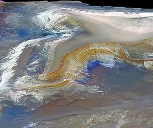
"Now users of the WorldWide Telescope can zoom down and actually experience the surface-level detail of Mars. They can pan back and see the height of the craters or the depth of the canyons. The new Mars experience allows people to feel as though they're actually there."

In particular, there's a new dataset from the University of Arizona's High Resolution Imaging Science Experiment (HiRISE), a state-of-the-art, remote-sensing camera on NASA's Mars Reconnaissance Orbiter.

HiRISE collects incredible images of super high resolution - a quarter of a meter per pixel on average. Each HiRISE image is a gigapixel in size, containing 100 times as much information as a 10 megapixel off-the-shelf camera.

"Due to its size, the data set is too unwieldy for many people to work with," notes Fay.

"But that large data set is necessary to provide the most in-depth experience - the most beautiful images, which are full of information. We needed this immense level of data to even begin to attempt to create this unique Mars experience."

To get those images out to the public in a new way, the team set an ambitious goal to take all of the HiRISE images, 13,000 or so, and stitch them onto a single coherent map.

While HiRISE has only imaged about 1 percent of Mars, leaving vast regions of Mars still to be explored, all of the HiRISE images have now been geolocated on a single map, and correlated with other global Mars data sets. Dotted with HiRISE images acquired so far, this new coherent map is the highest-resolution map of Mars' surface ever constructed.

"Not only is it going to be amazing for the general public to see, but it's actually something that scientists have never been able to see before," Broxton says. "This particular feat has never been attempted."

The reason for that, he says, is the technical challenge behind the project. The resolution of the images is so high and the files so large that NASA has been crunching the raw data for three years now. For anyone who's ever tried to edit a picture from a digital camera and had the computer spin on it for several seconds, multiply that by 100, or more. And then multiply the number of images by 13,000.

Multiply the number of tasks by another dozen and you can begin to see why the process has never been attempted. Broxton leveraged Nebula, NASA's high-performance computing cloud, to process the image data. In all, the HiRISE mosaic took 14 days to process on 114 CPUs and constitutes the entire collection that has been taken by the orbiting camera as of May 2010.

"It's an indispensible archive of information, but it's not very easy to access unless you have an expertise in processing lots of data," Broxton says. "Nebula allowed us to take the data, process it into a format appropriate for the WorldWide Telescope, and then make the entire catalog of NASA's Mars information available on desktops around the world through the WorldWide Telescope."

The images themselves reside on the Nebula cloud at the NASA Ames Research Center, near San Jose, California. Fay says hosting the data offsite is not a new approach, but rather one that allows WorldWide Telescope to use imagery from just about anyone.

Thanks to the magic of the cloud, other imagery on the site is hosted at Microsoft datacenters around the world. Hubble's resides in Baltimore. The California Institute of Technology's is in Pasadena.

"Anyone can actually put up their own astronomical images and view them through WorldWide Telescope," says Fay. "We've worked with folks at several other institutions to make their images available."

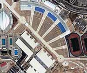
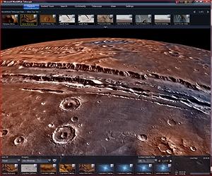
Retrieving images from all over the world is as smooth as any experience on the Web today. The secret is a tiling system that uses the visitor's desktop computer to process the imagery. With such a huge amount of information contained in one coherent tool, users are able to browse and zoom into interesting locations as they please.

Visitors to the WorldWide Telescope can now have the experience of flying though a 3-D rendering of Victoria Crater and Olympus Mons - a low valley and the highest peak in our solar system - and can experience firsthand the extreme elevation and intricate features on the Martian surface.

"We take advantage of the computing power you have on your desktop to allow a smooth, 3-D experience," explains Fay. "As you zoom in, it's a really constant view of these images. You can now get a true sense for what the terrain looks like."

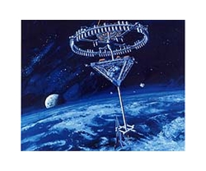
Broxton says the 3-D effect is derived from information provided by an instrument called MOLA, the Mars Orbiter Laser Altimeter, which measured altitude along the surface of Mars from space from NASA's Mars Global Surveyor orbiter. The team also combined that information with a stereo image-reconstruction process - taking two images from different angles and using that to build a 3-D model of the terrain.

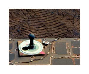
"These images give you a particularly visceral impression of, for example, the Mars Exploration Rover landing sites," Broxton says. "You can see what it's like in the hills there or zoom into surface craters. It's really amazing stuff."

For scientists and hardcore hobbyists, Fay's team at Microsoft has developed another feature that puts the image in the context of the mission from which it was collected. Users can right-click on some of the images and find their original Web pages at NASA with additional details on the HiRISE project.

"So it's not just the imagery, but bringing it together with the context," Fay says. "We think that capability will make this an exciting tool for scientists and educators."

So what is the surface of Mars like? According to Broxton, part of what's striking about Mars is its similarity to what we're used to here on Earth. Mars shares many of the same Aeolian (wind), tectonic, volcanic and even water processes, the effects of which are visible on the planet's surface.

"I often think of Mars as being a beautiful, barren, sculpted desert much like the American Southwest," Broxton says. "On earth, most of our craters have been erased because we have a much more active tectonic and volcanic process, but aside from that, there's a lot of similarity."

Back on Earth, Fay and his team are already looking at ways to continue building the WorldWide Telescope as a platform for advancing scientific learning, and a showcase for how technology can help facilitate understanding. He says that when he recently showed the new features to his son, the importance of that mission hit home.

"It gave my young son a sense of what the space mission is about, and why we as a nation invest in it," he says.

"I think that people who look at this will be amazed by these images and the detail of what these cameras can pick up. Seeing the solar system spinning in time, the details of the Martian planet, you could spend hours getting lost in space."

New Mars Tours Hosted By NASA Scientists
As part of the new Mars experience launched today on WorldWide Telescope, Microsoft Research and NASA are publishing interactive tours including two new virtual tours with NASA scientists Carol Stoker and James Garvin.

Dr. Stoker was a scientist on the Phoenix Mission team, which landed a rover near the north pole of Mars to look for conditions that might be conducive to life. In her tour, she explains the thought process behind the question "Is there life on Mars?" and what the Phoenix Mission did to assess whether Mars has had conditions favorable for life.

Dr. Garvin's tour walks through the history of Mars to establish why it's so interesting to us, and what a possible human mission to the Red Planet might entail.

Both tours are available in rich client application of the WorldWide Telescope.


www.marsdaily.com

Wednesday, July 14, 2010

Rosetta Triumphs At Asteroid Lutetia

0 comments


by Staff Writers
Paris, France (ESA) Jul 14, 2010
Asteroid Lutetia has been revealed as a battered world of many craters. ESA's Rosetta mission has returned the first close-up images of the asteroid showing it is most probably a primitive survivor from the violent birth of the Solar System.

The flyby was a spectacular success with Rosetta performing faultlessly. Closest approach took place at 18:10 CEST, at a distance of 3162 km. The images show that Lutetia is heavily cratered, having suffered many impacts during its 4.5 billion years of existence. As Rosetta drew close, a giant bowl-shaped depression stretching across much of the asteroid rotated into view. The images confirm that Lutetia is an elongated body, with its longest side around 130km.

The pictures come from Rosetta's OSIRIS instrument, which combines a wide angle and a narrow angle camera. At closest approach, details down to a scale of 60 m can be seen over the entire surface of Lutetia.

"I think this is a very old object. Tonight we have seen a remnant of the Solar System's creation," says Holger Sierks, OSIRIS principal investigator, Max Planck Institute for Solar System Research, Lindau, Germany.

www.spacedaily.com

Tuesday, July 13, 2010

Origin Of Key Cosmic Explosions Still A Mystery

0 comments


by Staff Writers
Cambridge MA (SPX) Jul 13, 2010
When a star explodes as a supernova, it shines so brightly that it can be seen from millions of light-years away. One particular supernova variety - Type Ia - brightens and dims so predictably that astronomers use them to measure the universe's expansion.

The resulting discovery of dark energy and the accelerating universe rewrote our understanding of the cosmos. Yet the origin of these supernovae, which have proved so useful, remains unknown.

"The question of what causes a Type Ia supernova is one of the great unsolved mysteries in astronomy," says Rosanne Di Stefano of the Harvard-Smithsonian Center for Astrophysics (CfA).

Astronomers have very strong evidence that Type Ia supernovae come from exploding stellar remnants called white dwarfs. To detonate, the white dwarf must gain mass until it reaches a tipping point and can no longer support itself.

There are two leading scenarios for the intermediate step from stable white dwarf to supernova, both of which require a companion star. In the first possibility, a white dwarf swallows gas blowing from a neighboring giant star. In the second possibility, two white dwarfs collide and merge. To establish which option is correct (or at least more common), astronomers look for evidence of these binary systems.

Given the average rate of supernovae, scientists can estimate how many pre-supernova white dwarfs should exist in a galaxy. But the search for these progenitors has turned up mostly empty-handed.

To hunt for accreting white dwarfs, astronomers looked for X-rays of a particular energy, produced when gas hitting the star's surface undergoes nuclear fusion. A typical galaxy should contain hundreds of such "super-soft" X-ray sources. Instead we see only a handful. As a result, a recent paper suggested that the alternative, merger scenario was the source of Type Ia supernovae, at least in many galaxies.

That conclusion relies on the assumption that accreting white dwarfs will appear as super-soft X-ray sources when the incoming matter experiences nuclear fusion. Di Stefano and her colleagues have argued that the data do not support this hypothesis.

In a new paper, Di Stefano takes the work a step further. She points out that a merger-induced supernova would also be preceded by an epoch during which a white dwarf accretes matter that should undergo nuclear fusion.

White dwarfs are produced when stars age, and different stars age at different rates. Any close double white-dwarf system will pass through a phase in which the first-formed white dwarf gains and burns matter from its slower-aging companion. If these white dwarfs produce X-rays, then we should find roughly a hundred times as many super-soft X-ray sources as we do.

Since both scenarios - an accretion-driven explosion and a merger-driven explosion - involve accretion and fusion at some point, the lack of super-soft X-ray sources would seem to rule out both types of progenitor.

The alternative proposed by Di Stefano is that the white dwarfs are not luminous at X-ray wavelengths for long stretches of time. Perhaps material surrounding a white dwarf can absorb X-rays, or accreting white dwarfs might emit most of their energy at other wavelengths.

If this is the correct explanation, says Di Stefano, "we must devise new methods to search for the elusive progenitors of Type Ia supernovae."

Di Stefano's paper has been accepted for publication in The Astrophysical Journal and is available online.Headquartered in Cambridge, Mass., the Harvard-Smithsonian Center for Astrophysics (CfA) is a joint collaboration between the Smithsonian Astrophysical Observatory and the Harvard College Observatory. CfA scientists, organized into six research divisions, study the origin, evolution and ultimate fate of the universe.

www.spacedaily.com